Highgate History
(In course of arrangement)
A simple animation of the development of Highgate and its environs from about 1835 to 1900:
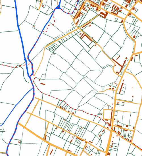
- The first frame shows the situation in about 1835 and is a composite redrawn from a pastiche of four old maps. The River Rea an associated channels are shown in blue, field and property boundaries in green, roads and tracks in yellow and buildings in brown. The boundaries between the parishes of Birmingham (top left), Aston (top right), Kings Norton (bottom right) and Edgbaston (bottom left) are indicated by dashed red lines. The boundary between Birmingham and Edgbaston to the west and Aston and Kings Norton to the east followed the River Rea, but straightening of its meandering course has already begun and the boundary between Birmingham and Aston leaves the new course of the river to follow its former course. The boundary between Aston and Kings Norton - which was also the county boundary - follows a line of field boundaries. So does the boundary between Birmingham and Edgbaston. The parishes come close to meeting at Vaughton's Hole, where a floodgate held back the Rea to divert water into an artifical chanel to feed a mill pond in Digbeth. This chanel was known as "the flem", a name derived from a Middle English word meaning a flow of water. (The same word is the origin of 'fleam' as the name for a lancet formerly used in blood-letting.)

In about 1831 Sir Thomas Gooch, who owned both the mill and the land through which the fleam flowed, pulled down the mill and removed the floodgate to drain the fleam and adjacent land so that he could lay out streets and build on it. His name is preserved by Gooch Street, which follows the course of the flem; current The maps that I have used are Pigot Smith's 1828 map of Birmingham, the 1833 Aston Parish tithe map, the 1827 Edgbaston Parish tithe map and the 1840 Kings Norton Parish Moseley Yield tithe map. Because the maps differ in date there has been more development in the bottom right corner with Belgrave Street, Sherborne Road and Balsall Heath Road laid out.
- The second frame shows in red the first temporary mission church opened in 1865 on Leopold Street superimposed on the 1866 town plan. At this time the future Stanhope Street was called Ryland Street.
- The third shows in red the second St Alban's Church opened in 1871 on the corner of Dymoke Street and Leopold Street with the District in pink on the 1890 OS map. The first building now served as a school room.
- The fourth shows in red the present St Alban's church opened in 1881 on the corner of Conybere Street and Stanhope Street; the second church is still marked as it continued in use as St Columba's Mission Church as well as serving as a school room.
- The final frame shows the situation in 1900. St Alban's Church is shown in red and St Patrick's Church, opened in 1896, has beed added to the 1890 map in green. In 1900 St Patrick's parish, in pale green on the map, was formed from part of St Alban's parish and areas taken from the parishes of St Paul, Balsall Heath, and St Thomas in the Moors.
[A further animation will show the subsequent union of the parishes and further changes to the parish.]